Tag Archives: public transport

Here’s a list of articles about public transport and how AddTransit can help with GTFS files, vehicle tracking, real time status updates and online ticketing.

Your Customers Expect Real Time Status Updates

Real Time Status Updates….

Customers expect Real Time Status updates

You know others are doing it.

But yes…. you’ve been putting it off.

You are fearful.  There’s a cost. People, systems and reputation.   So it’s been left to another day, another month, another year…

So what to do???  Let’s review each of these fears and see if we can turn these fears into an opportunity.

Your passengers/customers

Your customers and passengers are now expecting real time status updates.  They are tracking their parcels in real time across the globe.  They know if their Amazon book has left the warehouse, if their E-bay dress is in transit or if their pizza is just about to be delivered.  Their use of paper based maps for driving is now a increasingly historical novelty and GPS enabled smartphones is commonplace.  A decade ago it was normal not to know when things would arrive.  But now, not providing that information is seen as poor customer service.

Your team

Your team are already providing realtime status updates.  They do it by phone in the call center, at customer service centers, at stops/stations/ports and on vehicle.  However, this is a drain on your resources.  Imagine if customers/passengers could self-serve and obtain this information themselves.  This would free up your team.  They could focus on sales, upsell, and safety and instead of many team members providing best-effort updates, real time status updates allow you to ensure the right person provides the right information in the most efficient and cost effective way.

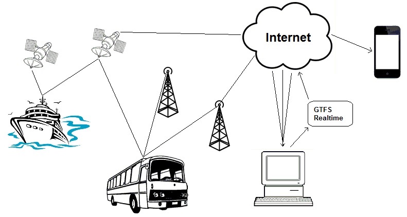
Realtime Status Systems and Software

In the past realtime status systems and software meant a massive cost investment.  Electronic signage was installed at key stops. Televisions and automated voice announcements were programmed.  Networking all these together was horrendously complicated.  And then if you wanted on vehicle realtime status systems you had to install triggers to let the vehicles know which stops had been passed and communications throughout the vehicles so all passengers could view the updates.

Luckily this huge cost outlay is no longer required.  With commuters now carrying smartphones, AddTransit can help you publish realtime status updates online.  This is a great opportunity as commuters care more about their journey, than the vehicles journey. Online realtime status updates are like Pizza delivery tracking.  You want to know how long it is until the pizza arrives at your house.  You don’t want to know all houses that the driver will delivering pizza to.  Online realtime status updates allow passengers to focus on just the information that is important to them, without being bombarded by updates that are irrelevant to their journey.  Real time status updates gives you the opportunity to provide passengers a personalized customer experience.

Your reputation

The other fear is the reputation.  The concern is that if your vehicles are late, you’ll be publishing this information for all to see.  This actually is a false fear.  Knowing that the vehicle is late allows passenger confidence in the system to rise, as now you have provided them with additional information giving them the opportunity to adjust their schedules.   Of course you’ll be looking for ways to improve on the service and minimise future delays, but in the meantime the real time status maps and apps will take the brunt of passengers displeasure with late services, and provide passengers reassurance for all the services that run perfectly.

The real time status updates opportunity

So the fears are false.  The opportunity is there.  The question now is poor customer service acceptable?  Or is it time to start real time status updates?

Find out more at https://addtransit.com/real-time-status.php

Or Join today and we’ll get you started.

Have a great day!

Cheap Vehicle Tracking Software using GTFS-Realtime

If you are looking for cheap vehicle tracking software, AddTransit is the right place.  Our smartphones apps allow you to track your vehicles and see their current position on a map.

Cheap Vehicle Tracking Software using GTFS-Realtime

So how does it work?

It is very simple, you just signup to AddTransit and then add each vehicle’s details.  You also add the users that will be allowed log into the system.

Then each of your users download the AddTransit app onto their GPS enabled smartphone.

Before they start to drive, they log into the app and select their current vehicle and their route or service. They press START and off they go.  The app keeps sending their location until they tell the app to stop.  Your smartphone is acting as a Vehicle Positioning System, but without the huge cost that is normally associated with such systems. Wow!

The vehicle location can then easily be seen in head office. If you enable GTFS Real-time (a standard that is for reporting realtime locations of vehicles), you can also make your vehicle locations available for your customers to see on internet mapping software such as Google, Bing or Yahoo Maps and journey planning apps.

No longer do you need to contact staff to find out where they are up to.  Your staff can concentrate on the safe travel of their passengers and giving these people a great customer experience.  Your passengers are even more excited as now they can know when their vehicle is approaching or is delayed and can plan accordingly.

Easy!

Have a great day.

Benefits of Public Transit

Transit Awareness Day is February 2, and we want to celebrate by listing a few of the many great benefits to taking public transit from countries around the world.

Benefits of Public Transit / Public Transport by AddTransit

Saves Money

The APTA says taking public transit can save an individual an average of $9453 a year in the United States. In the UK, a person can save over 3,000 pounds per year taking public transit instead of their car, according to Carbon Clever Commuter.

Reduces Pollution

OzeBus of Australia says, “Shifting from cars to public transport can deliver a 65 per cent emissions reduction during peak times and a 95 per cent reduction in emissions during off peak times from the commuters that make the shift.”

Taking the bus or train is a huge way for any individual to reduce their carbon footprint. Even buses that are heavy polluters take around 40 cars off the road every time they run, and most countries are adopting policies to make their buses as green as possible. In the UK, these buses are producing 30% less emissions of greenhouse gases.

Helps the Economy

Public transport provides jobs to operators and staff.

Australia estimates a reduction of $27 million per year in road crash costs and household savings of $176 million in fuel costs.

Because public transit encourages agglomeration, or the gathering of more people in the same place, the economic value can be anywhere from $1.5 million to $1.8 billion depending on the size of the city in the US.

Can Help You Get Fit

Public transit is a great way to get healthy. It can help you burn calories, get outside for more fresh air and sunshine, reduce depression and build healthy habits.

Is Safe

Public transit has about one tenth the number of traffic casualties as cars have, and transit travel has lower overall crime rates than automobile travel, making it a safe and secure way to travel.

Connects People with Community

When people ride the bus or train, they meet other commuters and form connections with their local community. It’s a great way to make friends and see more of your city.

Gives You Time to Work or Get Down Time

Of course, not everyone likes connect with other people during their commute. If you just want to be left alone, you can pop in some ear buds and take the time to catch up on work, read a book or take a nap, which is much more enjoyable than stressing out about traffic while you drive a car. Buses and trains are increasingly being equipped with WiFi so you can get even more done while you travel.

It’s Fun!

If you’ve ever ridden public transit with a little kid, you’ve seen how their eyes light up at the site of the oncoming train, they glue their faces to the window of the bus to see all of the exciting sites, and they’re nearly bursting out of their seats with the joy of the ride.  Be inspired by their happiness and enjoy the ride!

Transit News Round Up (Jan 25, 2016) – Latest Industry Updates

A roundup of transit news. What's happening with buses, trains, ferry and public transit.

Every day we find transit news that is relevant and useful to you. But if you missed these daily posts on Facebook, Twitter, Google+, Pinterest and Linkedin, you can find them all here in one place each week!

Here’s what happened in the transit world last week:

BUSES

Urban Dwellers Aren’t Abandoning Buses; Buses are Abandoning Them

This article from News Geography takes a look at why bus ridership is declining, and they say the data points to a decrease in bus service being the reason.

Should Colfax Give Up Car Lanes for Faster Bus Service?

Specifically about Denver, Colorado, but applicable to any city. Is this a trade worth making?

Back to College for Bus Workers

Bus Drivers in the UK are getting more than satisfying work and a paycheck from their jobs. They’re learning foreign languages and other fun and useful skills right out of the First Group bus company’s garages. What a great way for a company to care for the whole employee!

Euro VI Bus and Coach Registrations in 2015 Top 50%

Over half of the buses registered in 2015 met the Euro VI standard for emissions. The article talks about the reasons for this boost in compliance, and how the companies will continue to improve their reduction of emissions.

UK Bus Operators Make Case for Contactless Travel

Five leading bus companies, Stagecoach, First Bus, Go-Ahead, Arriva and National Express, are working to make contactless travel the standard in Britain by 2022.

All Electric Bus

Metro McAllen shared their excitement about their new all electric bus with a picture on Twitter.

SCHOOL BUSES

New School Bus Law to Improve Crossing Roads

Bus drivers in North Carolina are now using hand signals to let kids know if it’s safe to cross the road or not.

When a School Bus Full of Kids was Heading for a Ditch, This Boy Saved Them in the Most Amazing Way

14 year old Cory jumped into the driver’s seat and hit the brake when the bus driver became unconscious after a car hit the bus.

School Bus Fleet Launches New Website, New Look

Their new website is looking very nice with easier navigation and better response for mobile users. Check it out!

Connecticut District May Cut School Bus Aides

This school district wants to cut aides from its buses to save money, but some parents are in opposition. What do you think? Should all school buses have aides?

TRAINS

Transit Officials Unmask New CTrain Car

Check out Calgary Transit’s sleek new car! It’s “more reliable, more spacious, more accessible with a variety of new features.”

Hyperloop Transportation Technologies Breaks Ground to Make Elon Musk’s Hyperloop a Reality

The Hyperloop is a vacuum tube that will be able to transport passengers at 800 MPH from one major city to another at a fraction of the cost of high speed rail.

Gothard Base Tunnel Freight Tests Begin

Switzerland is testing the world’s longest railway tunnel, which will have regular service by the end of the year.

Lyon to Torino TBM Completed

France is working on tunnels for a high speed railway.

First Metrolink F125 Completed

Metrolink in Los Angeles, California will have it’s first F125 Spirit diesel locomotive.

London Suburban Metro and Local Input to Franchising Proposed

The Department for Transport and Transport for London are working together to potentially create a London Suburban Metro.

Bus, train, ferry and public transport news.

STEAM TRAINS

Visitors Enjoy Steam Town on MLK Day, First of Several Free Admission Days Planned for 2016

The National Historic Site offered free admission on Martin Luther King Jr. Day, so families could come learn about the history of steam trains.

PUBLIC TRANSPORT

County to Provide Free Bus Passes for Those Registering to Vote

Milwaukee County will spend up to $20,000 to provide free bus passes for voters.

DOT Secretary Foxx Outlines Infrastructure Vision

US Department of Transportation Secretary Anthony Foxx discussed the infrastructure deficit and ways to improve planning for transportation dollars.

Top 10 Reasons to Thank Congress

The American Public Transportation Association lists 10 reasons to thank the US Congress for passing the FAST Act, the first long term transportation bill in 10 years.

A Good Transport Plan for Bristol

SusTrans lays out a plan that’s greener, cheaper and more efficient than reliance on fossil fuels.

TOUR OPERATORS

Polk County Orange Juice Being Flown to Iceland to Promote Polk Country Tourism at International Travel Tradeshow

Orange juice is being flown in to the 2016 Icelandair Mid-Atlantic Trade Show to show off one of Florida’s best features.

We’d love to hear from you!  Let us know what you think about any of these topics.

Add Google Maps Public Transport directions to Your Event/Website

Here’s the three steps to add Google Maps Public Transport directions to your website.

1. Check if Google Maps has Public Transport directions for your location

Click on the following link to find out if Google Maps has public transport information for your event’s location:

https://maps.google.com/landing/transit/cities/ 

If Google has public transport for your event’s location.. Great!!  Then go to the Example (step 2) below.

If they don’t have public transport for your event’s location. It might be because your public transport provider has not yet provided Google the data in the correct format.  We suggest you contact your public transport provider and suggest they get their data on Google Maps.  If they don’t know how or need help, tell them about AddTransit or send them a link (https://addtransit.com) and we can help get their public transport (ferries, buses, trams and trains) onto Maps.

2. An Example: Public Transport Directions Using Google Maps

Here’s an example of it could look. We’ve used “Times Square, New York” as the event destination.

Try entering Boston, MA as the starting address…..


3. Add this code

Here’s the code that you will need to add to your website.  You’ll need to modify the “Times Square, New York, USA” to be the address of your event.

<form action=”https://maps.google.com/maps” method=”get” target=”_blank”>
<label for =”saddr”>Enter your starting address: </label>
<input type=”text” name=”saddr” />
<input type=”hidden” name=”daddr” value=”Times Square, New York, USA” />
<input type=”hidden” name=”dirflg” value=”r” />
<input type=”submit” value=”Show Journey” />
</form>

Publish the updated webpage and that’s it!  Done!

Hope that helps and let us know if you have any questions.

Have a great day!

Create GTFS Data Feeds with our GTFS Tool

Getting your company’s data appearing on Google Maps, Bing Maps,  Transit Apps and other transport software is mandatory these days.  Your passengers and customers expect to be informed all the time and when you don’t meet their expectations they become disgruntled, interact negatively with your front-line staff and drag down the reputation of your company.

But for many companies getting onto such sites is a technological challenge that is beyond them or a cost that is not factored into the budgets.  AddTransit aims to make it easy and affordable to get your transport business appearing online.

So how do you do it?

Create GTFS Data Feeds - GTFS Tool

You need to create a GTFS Data Feed and the easiest way to create a GTFS data feed is with a GTFS Tool.

GTFS Data Feed

A GTFS Data Feed is a special computer file that contains data about your route, schedule and stops/stations. GTFS is an acronym for General Transit Feed Specification.  This specification was originally developed in partnership between a public transport operator and Google.  Since then the specification has become the defacto standard for all the major internet companies (e.g. Bing, Yahoo, etc.) and also for all the smartphone, mobile and cell phone public transport and transit Apps.

The GTFS Data Feed allows you provide your transit data in single feed to all these companies; a single update that becomes accessible to all your passengers, everywhere, all the time.

GTFS Tool

When you want to create GTFS data feeds, the easiest way is using a GTFS Tool.  The GTFS tool ensures that the data is in the correct format and enforces consistencies and GTFS validations.  The tool should provide an intuitive user interface, the ability to verify geographic data on maps and where possible, prevent user errors.

The GTFS tool should allow you to easily export your first schedule and make changes to your schedule, route or stops a simple maintenance function.  We also recommend an online tool, so that if the standard changes, you will automatically get the updated software.

What Next?

Well, if you’d like to get your schedule, routes, stops onto Maps.  If you’d like to make it easier for your passengers and customers to access your timetables and plan their journeys.  Or if you’d like passengers to self serve and reduce questions and queries to front line staff, then we recommend you Join AddTransit and get started.

Have a great day!


Get Fit with Public Transit

It’s New Year’s Resolution time, and one of the most popular resolutions is getting in shape.

But what if we told you that you don’t need to get a gym membership, buy a treadmill, or start an implementing an elaborate workout plan?  You just need to implement simple, consistent habits, and public transit can help.

You already have a way to get to and from work, the grocery store, and your kid’s karate class.  Your mode of transportation is a habit, whether you walk, drive or take the bus.

According to the book The Slight Edge, “There are two kinds of habits: those that serve you, and those that don’t.”

You can make your mode of transportation serve you by also making it part of your workout routine.

In many decent sized cities, most people live about ¼ mile away from a public transit stop.  If you walk to the bus stop, then from the bus stop to your place of work, and reverse the trip on the way home, you’ll achieve a mile of walking per day.  According to livestrong.com, while walking one mile “a 135-pound  (61kg) person burns about 78 calories per mile, while a 165-pound (75kg) person burns about 96 calories during a walk of the same speed and length.”

If 96 calories doesn’t sound like much to you, you can do a few things to increase that number. Walking faster, walking up hills, and adding light hand weights are all ways to burn more calories.

Of course, getting fit isn’t just about burning calories.  Increasing flexibility improves circulation and posture, and reduces stress and risk of injury.  You can do cat-cow poses, tree poses, and shoulder shrugs right on the bus or train.

That walk to and from the public transit stop will also get you outside in the fresh air and sunshine, which can be especially hard if you work during all of the winter daylight hours.  Sunshine is thought to cause your brain to release a hormone called serotonin, which can help ward off depression.  Sunshine also causes your body to create vitamin D, which is important for bone health.

While using your public transit trip as your workout routine might not prepare you for the Olympics or give you the physique of a body builder, it does have the benefits of being easy to implement.  Often our elaborate plans sound great on paper, but our motivation quickly fades.  Implementing small steps, consistently, as part of a larger habit, is key to making lifestyle changes that actually stick long term.

If you’re already taking public transit, that’s a great start!  If not, get your local bus or light rail schedule and start getting healthier today.


Rail ticket booking software

Paper railway tickets sold by a conductor have now almost universally been replaced by rail ticket booking software.  The methods for sale, verification of correct purchase before and during travel and when alighting, whilst monitoring passenger numbers and sales costs  have greatly changed.

Nowadays passengers expect to be able to purchase their tickets any hour of the day, irrespective of whether they are near the train line or not.  They expect convenience.  Yet rail companies personnel  budgets are tight.  So many rail companies have adopted a high upfront cost approach by installing expensive hardware at multiple locations to sell tickets.  Unfortunately these machines also have an ongoing cost resulting from maintenance, repair, connectivity, servicing and replacement.  Sooner or later the railway looks to find a way to reduce this cost too.

Other options including selling your tickets through stores and other shops that passengers may frequently visit. However, your company is not their key focus so your brand is lost amongst their many other products.

Many larger railways have adopted electronic cards, similar to a bank card ranging from just an electronic strip where the balance is stored on a head office computer system, or with more advance electronics where the balance is stored on the card itself and then is updated to the head office computer system every now and then.  These cards have great benefits in that you can now track where the passenger boards and alights, thus giving you detailed statistics on passenger numbers.  However, they also have huge costs as trains or stations or both need to be fitted with the necessary hardware to sell, verify and process passengers.

And then there is the challenge with vending machine sales and electronic cards of end of life.  Typically the installation of all the related hardware occurred at one point in time.  It involved a massive upfront cost, significant deployment of contractors or personnel to install the machines, and costly multi-year contracts with vendors.  Then 5, 10, 15 years later they all must be reviewed again.  And the vendors now have a almost monopoly position able to lift their prices, because only they know how to fix your system.

Well, there is now a new solution to this.  The humble smartphone, mobile phone, cell phone (call it what you will) and the internet allows you a new way forward.  Your customers now carry mobile phones and using AddTransit rail ticket booking software for your sales and reservations you will be able to implement a new network wide ticketing solution almost immediately.  Mobile apps allow the purchase of tickets and the verification of tickets.  Customers have the flexibility of 24×7 purchase and reservations no matter where they are.  And you have the location based reporting so that you can improve your routes and timetables whilst monitoring your costs.

Find out more about our Railway Ticket Booking Software today.

Bus Ticketing Software – 7 Keys to Success

Here are 7 key things that your Online Bus Ticketing Software should have for you to be successful.

1. Journey planner

You software should allow your passengers to review a number of different journey options to allow them to determine the best route and time to accomplish their journey.

2. Online Ticket Payments

The system should allow passengers to make payment immediately whilst they are online booking the tickets.  Online ticket payments provides passengers the convenience and comfort of knowing their journey is secured, whilst at the same time reduces the likelihood of them looking at at alternative travel options.  Online payments is likely to increase your revenue whilst at the same time reduces the cash/payment handling at the front line.

3. Email Confirmation of Ticket Bookings and Reservations

The passengers should receive an email confirmation so that they fully understand what travel they have booked.  An email also allows them to refer back to their booking at a later date and will reduce the number of customer queries.

4. Passenger Manifest

A passenger manifest must be able to be produced for the driver or if available, the bus conductor or host.  This makes it quicker and easier for them to verify the correct passengers are boarding and departing the bus at each stop.

5. Customer Service Functionality

Passengers will consider online booking as just one more channel for them to communicate and transact with your business.  This means that customer service staff who answer telephones, work at ticket desks, etc. need to be able to review booking and travel information and make any necessary changes that are allowable within your bookings and reservation policy.

6. Reports (e.g. Forward Capacity, Historical Capacity Reports)

Your bus ticketing software should provide a number reports that allow you to plan both short and long term.  Such reports include capacity reports, that allow you to see how much spare capacity a vehicle has today or in the retrospective sense, how much capacity a vehicle had for a similar trip in the past.  This allows you to determine if additional capacity needs to be made available.

7. Payments

Of course online bus ticketing software is only a success if you get paid quickly.  You need to be able to ensure that the passengers fares gets to you quickly while at the same time maintaining a small float for any refunds that may need to be issued.

Well that’s the 7 keys to success.  There’s plenty of other things to consider, but having these 7 fulfilled will put you in a good position.

Have a great day!

How Real Time Transit Information works

Today, we thought we’d have a quick look at how real time transit vehicle tracking works…

Real time transit information
How Real time transit information works

The diagram above provides a simplistic representation on how vehicles positions are determined and then combined to provide real time transit information on a mobile phone.

Firstly the vehicle typically has an on-board Global Positioning System (GPS) device.  The GPS device uses signals from satellites, telecommunication towers and even local wifi to determine where the vehicle is physically located.  The amount of signals available will depend on the vehicle, it’s location and the specifications of the GPS device.  The greater number of signals that the device has access to, the more accurate it can be.

The GPS device will determine its position in terms of latitude, longitude and also provide a level of accuracy.  The vehicle will then transit the GPS location and some identifying information (e.g. a vehicle id, route id, etc.) via the internet to a computer.

The computer then combines a variety of vehicle’s GPS positions to produce the data in the form of a GTFS real time (GTFS-RT) data feed.  This data feed’s standardized GTFS realtime format makes it easy for Google and the various transit apps developers to display many bus, ferry, train and public transport companies information in a consistent way.  The position can be displayed on laptops, PC’s or tablets.  As the vehicle moves along, the updated position is passed through this process, allowing the end-user to identify the location of the vehicle and make informed decisions about their travel journey.

Well… that’s the simple explanation. We’ll delve into the detail in future posts.

Have a good weekend.