Category Archives: Vehicle Positioning

Articles describing how Vehicle Positioning on Maps works and how you can set it up for your company.  Track your fleet, monitor your ferry locations, follow your shuttles and/or buses, and predict the arrival of your trains.

GTFS Tools – GTFS Builder, GTFS Editor and GTFS-Realtime

Getting your bus, train, ferry and public transport onto maps and apps requires GTFS Tools.  AddTransit has a set of GTFS tools that allows you start simply and then build up to more complex realtime updates.

GTFS Tools

Our GTFS tools include:

  • GTFS Builder / GTFS Editor
  • GTFS-Realtime Status updates
  • GTFS-Realtime Vehicle Tracking

Let’s discuss each of these in turn…..

GTFS Builder / GTFS Editor

GTFS Editor, GTFS Builder & other GTFS Tools

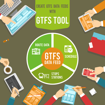
Our GTFS builder / GTFS editor allows you to create the initial GTFS file.   We step you through your agency details, the scheduled days that you operate, the routes, individual trips and stops information.  This allows you to easily build your GTFS file.  If you have existing data in stored in files (e.g. CSV, MS Excel), we even be able to upload the data for you and greatly speed up the creation of the GTFS file.  Once all the necessary information has been entered, then you can create your first GTFS file.  We can host the GTFS file for you, or you can host it on your own servers.  When your stops, routes or schedules change, you can easily log into our secure online website and use the GTFS Builder / GTFS editor to update your data.  When you are ready you can also add information about transfers, wheelchair and bike capacities, fares and route maps.

GTFS-Realtime Status Updates

GTFS-Realtime status updates

When delays affect a planned service, GTFS-Realtime status updates allow you to keep your passengers informed. You can provide customer information on what is causing the delay and what the effect will be on passenger’s travel.  The level of detail you provide is up to you. You can even provide a URL to pages on your company’s website to give even more detail.  AddTransit for GTFS-Realtime status updates can be provided to all online map, apps and journey planning providers.  This allows your passengers to choose their preferred devices and software providers.  Allowing your status updates to be displayed on many different online maps, apps and journey planners will result in the maximum number of customers being informed.

GTFS-Realtime Vehicle Tracking

GTFS-Realtime Vehicle Tracking

GTFS-Realtime Vehicle Tracking solves the problem of customers not knowing when their bus, train or ferry is about to arrive.  Using a free App on a GPS enabled smartphone with secure AddTransit login details, you can upgrade your AddTransit account to include GTFS-RealTime (GTFS-RT) Vehicle Tracking.  Initially, your staff can monitor your vehicles on the AddTransit website. When you are ready, you can also provide vehicle positions in a GTFS -Realtime file for all online map, apps and journey planning providers to use.

Related Posts:

https://addtransit.com/blog/tag/gtfs-editor/

Online Real-time Vehicle Tracking Software

Online real-time vehicle tracking software gives you the ability to view your bus positions, locate your trains and monitor your ferries or trams wherever they are.  Additionally, you can provide this same information to passengers so that they can plan their journeys and so that their friends and families can have the security of knowing when they will depart and arrive.

Real Time Vehicle Tracking Software

Vehicle Tracking Software – The Technology

AddTransit’s technology is easy to deploy.  There is no need for IT consultants or hardware that costs tens of thousands of dollars.  Instead we just add an app to a GPS enabled smartphone or tablet which is carried on the vehicle.  With the accuracy of smartphones now being approximately the size of a vehicle in an area with good mobile/cell coverage, this enables the vehicle location to easily be pinpointed.

The smartphone or tablet, then sends a secure signal using the HTTPS protocol to our servers, which then display the location on a map.

Secure and Accurate Vehicle Tracking

To ensure secure and accurate vehicle tracking, each vehicle is has its a unique identifier (e.g. a Licence Plate or Registration Number) entered and the on board company representative (e.g. driver, pilot, or other staff member) has to login.  Key trip details are also selected so that you can know which vehicle, company representative is currently logging the vehicles location.

Online  Vehicle Tracking- The Display

Tracking bus positions, or other vehicles locations is then as simple as logging into the AddTransit website.  The location of the bus, ferry, train or tram are shown on map and update at regular intervals. Depending on your need, you can select to monitor a particular vehicle, trip or route.  As the solution is online and real-time, you can monitor your vehicles from wherever your staff need to.  For example, your staff could monitor your vehicles from both the head office and from ticket sales locations, depots or docks.

Vehicle Tracking Apps, Journey Planners and Maps

Using AddTransit’s online real-time vehicle tracking also enables you to have your vehicle’s locations displayed on vehicle tracking apps, journey planners and maps.  We can provide a GTFS Real-time data feed which can be used by companies such as Google, Microsoft and Yahoo to display your vehicle’s locations on their maps.

Contact us to find out more or Sign up today!

Cheap Vehicle Tracking Software using GTFS-Realtime

If you are looking for cheap vehicle tracking software, AddTransit is the right place.  Our smartphones apps allow you to track your vehicles and see their current position on a map.

Cheap Vehicle Tracking Software using GTFS-Realtime

So how does it work?

It is very simple, you just signup to AddTransit and then add each vehicle’s details.  You also add the users that will be allowed log into the system.

Then each of your users download the AddTransit app onto their GPS enabled smartphone.

Before they start to drive, they log into the app and select their current vehicle and their route or service. They press START and off they go.  The app keeps sending their location until they tell the app to stop.  Your smartphone is acting as a Vehicle Positioning System, but without the huge cost that is normally associated with such systems. Wow!

The vehicle location can then easily be seen in head office. If you enable GTFS Real-time (a standard that is for reporting realtime locations of vehicles), you can also make your vehicle locations available for your customers to see on internet mapping software such as Google, Bing or Yahoo Maps and journey planning apps.

No longer do you need to contact staff to find out where they are up to.  Your staff can concentrate on the safe travel of their passengers and giving these people a great customer experience.  Your passengers are even more excited as now they can know when their vehicle is approaching or is delayed and can plan accordingly.

Easy!

Have a great day.

Are you ready for New Years?

The New Year is coming right up, and along with the fun and festivities come some challenges like dealing with intoxicated or unruly passengers.  We want your transit company to have a safe New Year’s Eve, so we’ve compiled some ideas to help the night go smoothly.

Happy New Year from AddTransit

Review records of incidents in prior years to identify locations that were hot spots for trouble.  You can use this information to co-ordinate with authorities and see if extra patrols would be advisable, and to schedule your security services if you employ them.

Make sure your security cameras are in proper working order, so you can record any incidents if they do occur.  This is also a good time to test panic buttons.

Schedule a meeting with your operators this week for a review of safety procedures.  They should have training on how to recognize intoxication or drug use, how to defuse potentially volatile situations and how to handle unruly passengers.  Encourage your operators to be professional and firm in enforcing fares and rules, but not to the point of escalating conflict or risking personal harm.

The Transit Cooperative Research Program recommends courses in verbal judo, which can teach operators de-stressing techniques, how to “calm a hostile customer and diffuse a potentially violent situation.”  If you have provided your operators with self-defense training, this is a good time to brush up on those techniques.  If not, consider offering this instruction as soon as possible in the coming year.

Also, keep in mind that this is a difficult time of year for many people, and your operators may have just had a hard holiday season themselves.  It will be hard for them to smooth the ruffled feathers of passengers if they are dealing with stress or grief themselves.  Take some time to check in with each employee and see if there are any steps you can take to boost morale.

Combining Vehicle Tracking  that shows the location of the transit vehicle at all times with Real Time Status Updates to notify your passengers of delays or route changes can be beneficial, will allow you to keep riders informed of changes or delays.

Have a great New Years and stay safe.

Online Vehicle Tracking Software (Real Time)

AddTransit’s online vehicle tracking software gives you cheap vehicle tracking in real time.  Combining the power of GPS equipped smartphones, the Internet and custom built cloud based software results in cheap vehicle tracking for your bus, transit or transport tourism business.

Online Vehicle Tracking

Using our apps or mobile Internet pages your drivers can login and choose their route and vehicle.  The GPS enabled smartphones then provide the position of the vehicle as they travel along the route.

The vehicles location can be viewed on AddTransit’s online vehicle tracking web pages in real time.  We can also use the GTFS (General Transit File Specification) real time format to provide the vehicle positions to App providers and Google Maps.

It’s quick to set-up, easy to use and good value.

Have a great day!

Create GTFS data feeds / GTFS Software

Creating GTFS data feeds can mean a couple of things.  It can mean creating the the static General Transit File Specification file which contains the basic information about the schedule, stops, routes with optional information such a fares and maps.  But it can also mean creating realtime status updates (GTFS Realtime) and providing data that shows your vehicles current positions.

Although you can use text editors to create GTFS files or excel templates, the reality is that these are not inherently designed to ensure that the interdependencies between files are maintained and the risk of human error overriding the basic checks remains high.  Additionally, they are not fully integrated with mapping and timetable functions so that there is a lot of switching between software.  If you are an extremely well funded transportation company then you may get GTFS functionality as part of or an add-on to your existing enterprise transportation software package.  But for the majority of other companies, GTFS Software such as AddTransit.com that is specifically designed to create GTFS files and realtime data is the ideal solution.

GTFS software should be simple and easy enough to deliver the basic schedule for a small shuttle bus company while at the same time robust enough to handle complex scheduling and real-time solutions for citywide public transport and interstate/multi-country transit, ferry and airline companies.

This is our aim every day at AddTransit…. to make transportation easier.

Have a great day.

How Real Time Transit Information works

Today, we thought we’d have a quick look at how real time transit vehicle tracking works…

Real time transit information
How Real time transit information works

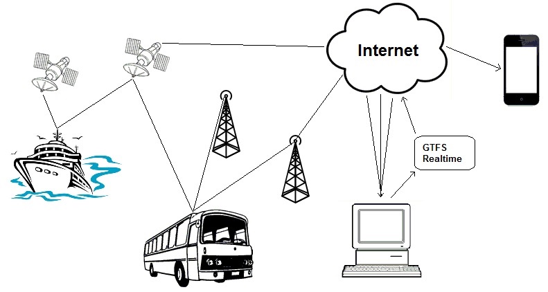
The diagram above provides a simplistic representation on how vehicles positions are determined and then combined to provide real time transit information on a mobile phone.

Firstly the vehicle typically has an on-board Global Positioning System (GPS) device.  The GPS device uses signals from satellites, telecommunication towers and even local wifi to determine where the vehicle is physically located.  The amount of signals available will depend on the vehicle, it’s location and the specifications of the GPS device.  The greater number of signals that the device has access to, the more accurate it can be.

The GPS device will determine its position in terms of latitude, longitude and also provide a level of accuracy.  The vehicle will then transit the GPS location and some identifying information (e.g. a vehicle id, route id, etc.) via the internet to a computer.

The computer then combines a variety of vehicle’s GPS positions to produce the data in the form of a GTFS real time (GTFS-RT) data feed.  This data feed’s standardized GTFS realtime format makes it easy for Google and the various transit apps developers to display many bus, ferry, train and public transport companies information in a consistent way.  The position can be displayed on laptops, PC’s or tablets.  As the vehicle moves along, the updated position is passed through this process, allowing the end-user to identify the location of the vehicle and make informed decisions about their travel journey.

Well… that’s the simple explanation. We’ll delve into the detail in future posts.

Have a good weekend.

GTFS RealTime Status News

Today (Wed, 3 June 2015)there has been a flurry of news articles about GTFS Realtime Status.

Why? Well, because yesterday in the Google Map’s Blog,  Karen Grunberg the Technical Program Manager from Google Transit announced that they are adding 25+ new location for real-time transit info across six places: U.K., Netherlands, Budapest, Chicago, San Francisco, and Seattle.  She goes on to say “This real-time transit info will let you see live arrivals for buses, metros and subway systems—and even alert you to cancelled routes—so you can better navigate the intricate and unpredictable world of transit in major cities around the world.”

Here’s the link to her blog post (http://google-latlong.blogspot.com.au/2015/06/mind-gapp-for-real-time-transit.html).

Kelsey Campbell-Dollaghan follows on in an article on Gizmodo (http://gizmodo.com/google-just-made-it-easier-to-see-exactly-how-late-your-1708532452) with a couple of nice screen shots showing how a 4 minute delay for  bus trip would be displayed.

So in you’re not online yet, how do you get your cities real-time data online?  Well, in Seattle’s case it helped that Brian Ferris, the developer of the widely used OneBusAway app, was hired by Google (http://www.geekwire.com/2015/onebusaway-creator-brings-seattles-real-time-transit-data-to-google-maps/).  But for everyone else the best way is to create a GTFS real-time transit feed.  GTFS is the acronym for General Transit Feed Specification, the international standard for displaying schedule and other transit information.

If you want to know more about  how to create GTFS realtime status or how to track a vehicles location using GTFS, just contact us.

One final comment: It seems like forever to get to this many cities with realtime data, but in reality Google only launched their realtime transit status service in 2011, only four short years ago (http://googleblog.blogspot.com.au/2011/06/know-when-your-bus-is-late-with-live.html)

Have a great day!