Tag Archives: ferry

Articles about ferries. Includes ferry GTFS, shipping tracking and location, real-time alerts, online ferry ticketing and the latest ferry news.

Take Transit to See Mum for Mothering Sunday

Mothering Sunday is March 6 in the UK, and if you’re planning to go see Mum, there are no shortage of transit options.

Take Transit to See Mum this Mothering Sunday

Ferries

The UK offers over 100 ferry routes to France, Ireland, Belgium, Spain and more!  This is a great option if you want to have your car with you when you get to your destination.  Does mum live closer than a ferry ride away?  Pick her up and take her on an outing!  Take the ferry, then take a drive through the countryside.

Coaches

Coaches are a lovely way to get around Britain, allowing you to relax and enjoy the sights instead of worrying about driving.  They’re also one of the least expensive ways to travel, so if you’ve thought that you couldn’t afford to see Mum this year, maybe an inexpensive coach ride is the way to go.

Channel Tunnel – An Undersea Train

If you need to quickly get from London to Paris, the undersea train can get you there in just over 2 hours.  There aren’t many places in the world where you can hop over to another country for lunch, so take advantage of where you live and take mom out to see the sights and enjoy some new cuisine.

Bus & Rail

For smaller, local trips, bus and rail offer convenience and speed.  You don’t have to worry about parking your car or the wear and tear on your vehicle.  If Mum takes a ride with you, and she’s worried about safety, let her know that the bus and train are safer than driving.  Traveling this way will also give the two of you the chance to fully connect with each other during the ride, rather than you being focus on traffic.  And if you have kids and bring them along, they’ll love the bus or the train, and Grandma will love watching their excitement!

Whichever way you choose to see Mum this year, we hope you have a lovely day together!  Happy Mothering Sunday from AddTransit!


Your Customers Expect Real Time Status Updates

Real Time Status Updates….
Customers expect Real Time Status updates

You know others are doing it.

But yes…. you’ve been putting it off.

You are fearful.  There’s a cost. People, systems and reputation.   So it’s been left to another day, another month, another year…

So what to do???  Let’s review each of these fears and see if we can turn these fears into an opportunity.

Your passengers/customers

Your customers and passengers are now expecting real time status updates.  They are tracking their parcels in real time across the globe.  They know if their Amazon book has left the warehouse, if their E-bay dress is in transit or if their pizza is just about to be delivered.  Their use of paper based maps for driving is now a increasingly historical novelty and GPS enabled smartphones is commonplace.  A decade ago it was normal not to know when things would arrive.  But now, not providing that information is seen as poor customer service.

Your team

Your team are already providing realtime status updates.  They do it by phone in the call center, at customer service centers, at stops/stations/ports and on vehicle.  However, this is a drain on your resources.  Imagine if customers/passengers could self-serve and obtain this information themselves.  This would free up your team.  They could focus on sales, upsell, and safety and instead of many team members providing best-effort updates, real time status updates allow you to ensure the right person provides the right information in the most efficient and cost effective way.

Realtime Status Systems and Software

In the past realtime status systems and software meant a massive cost investment.  Electronic signage was installed at key stops. Televisions and automated voice announcements were programmed.  Networking all these together was horrendously complicated.  And then if you wanted on vehicle realtime status systems you had to install triggers to let the vehicles know which stops had been passed and communications throughout the vehicles so all passengers could view the updates.

Luckily this huge cost outlay is no longer required.  With commuters now carrying smartphones, AddTransit can help you publish realtime status updates online.  This is a great opportunity as commuters care more about their journey, than the vehicles journey. Online realtime status updates are like Pizza delivery tracking.  You want to know how long it is until the pizza arrives at your house.  You don’t want to know all houses that the driver will delivering pizza to.  Online realtime status updates allow passengers to focus on just the information that is important to them, without being bombarded by updates that are irrelevant to their journey.  Real time status updates gives you the opportunity to provide passengers a personalized customer experience.

Your reputation

The other fear is the reputation.  The concern is that if your vehicles are late, you’ll be publishing this information for all to see.  This actually is a false fear.  Knowing that the vehicle is late allows passenger confidence in the system to rise, as now you have provided them with additional information giving them the opportunity to adjust their schedules.   Of course you’ll be looking for ways to improve on the service and minimise future delays, but in the meantime the real time status maps and apps will take the brunt of passengers displeasure with late services, and provide passengers reassurance for all the services that run perfectly.

The real time status updates opportunity

So the fears are false.  The opportunity is there.  The question now is poor customer service acceptable?  Or is it time to start real time status updates?

Find out more at https://addtransit.com/real-time-status.php

Or Join today and we’ll get you started.

Have a great day!

Add Google Maps Public Transport directions to Your Event/Website

Here’s the three steps to add Google Maps Public Transport directions to your website.

1. Check if Google Maps has Public Transport directions for your location

Click on the following link to find out if Google Maps has public transport information for your event’s location:

https://maps.google.com/landing/transit/cities/ 

If Google has public transport for your event’s location.. Great!!  Then go to the Example (step 2) below.

If they don’t have public transport for your event’s location. It might be because your public transport provider has not yet provided Google the data in the correct format.  We suggest you contact your public transport provider and suggest they get their data on Google Maps.  If they don’t know how or need help, tell them about AddTransit or send them a link (https://addtransit.com) and we can help get their public transport (ferries, buses, trams and trains) onto Maps.

2. An Example: Public Transport Directions Using Google Maps

Here’s an example of it could look. We’ve used “Times Square, New York” as the event destination.

Try entering Boston, MA as the starting address…..


3. Add this code

Here’s the code that you will need to add to your website.  You’ll need to modify the “Times Square, New York, USA” to be the address of your event.

<form action=”https://maps.google.com/maps” method=”get” target=”_blank”>
<label for =”saddr”>Enter your starting address: </label>
<input type=”text” name=”saddr” />
<input type=”hidden” name=”daddr” value=”Times Square, New York, USA” />
<input type=”hidden” name=”dirflg” value=”r” />
<input type=”submit” value=”Show Journey” />
</form>

Publish the updated webpage and that’s it!  Done!

Hope that helps and let us know if you have any questions.

Have a great day!

Ticket booking software (Bus, Train, Ferry, Tours)

Online Ticket Reservations (Bus, Ferry, Train, Tours)

Online ticket booking software for bus, train, ferries and tours is now available at AddTransit.  Easily add your schedule, key stops and fares, add a link to your website and you are up and running!

In the past, you had to hire web specialists to create custom ticketing systems for you, but now with AddTransit you can be set up and running quickly.  You can focus on the things  that matter, while tickets are sold online.  Of course, there are administration functions that allow you to monitor bookings, capacity and make changes to bookings if passengers need assistance.

The benefits of online ticket booking software means that reservations for your bus, train or ferry service or bookings for your tours, can be managed by the customers themselves.  This allows them 24×7 flexibility in booking 365 days of the year,  removes the need to queue at your ticket counters, and allows your staff to focus on providing greater value.

We encourage you to try AddTransit for yourself.

Have a great day.

GTFS – Why you are missing out on Passengers

Increasingly, online maps and journey planning apps are the new “someone to ask” about how to get somewhere and it’s highly likely your business is not the answer they are giving…

It used to be enough just to get to #1 on Google search results.  However, that’s changed with the advent of Location Based Searches and Journey Planning smartphone Apps.  If your business involves taking passengers from A to B (and maybe back again), then to compete properly you now need your timetable, pickup and drop-offs appearing in these search results and journey apps.

More and more, tourists and irregular travellers are relying on these online mapping services to find their way around unfamiliar places and if your business is missing from these search results, then it’s highly likely they’ll choose one of the other alternatives offered.

To see if you or a business you know is missing out try this quick test.  Go to the following page (https://addtransit.com/missing-out.php) and enter one of the business’s pickup and destination locations.  If the business’s timetable and services do appear, then well done!  Otherwise, read on.

So, how do you get onto the online maps and journey planners?  Unfortunately, the schedule or timetable on your webpage, or your own custom built journey planner is just not enough.

You will need to create a GTFS file.  A GTFS file is a special type of file that contains information about your business, its schedule and timetable, and its routes and stops including their latitudes and longitudes.  The GTFS file is used by the online maps and journey planners to add your data to their systems.  There’s a number of ways to create a GTFS file, but if you have limited time or technical skills then getting a company such as AddTransit.com to do it for you, is a quick and cost effective solution.

Once the GTFS file is created, then you need to get the companies that use GTFS files to use it.  This normally involves adding a link on your website and submitting it to both GTFS directories and to the various search engines and journey planning app companies.  Each company has different submission forms, timeframes, and acceptance conditions.  If you got a company to create the GTFS file for you, then they should submit it for you.  Otherwise you’ll have to learn how to do it yourself.

Of course your timetable, stops and routes will change, so like all your marketing and customer service information, it’s important to keep the GTFS file up to date.  That way your passengers should be able to see your latest information.

Best of luck and have a great day.

How Real Time Transit Information works

Today, we thought we’d have a quick look at how real time transit vehicle tracking works…

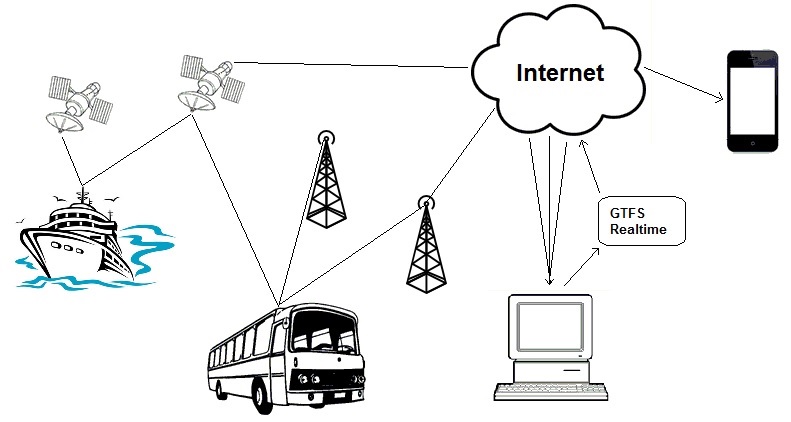
Real time transit information
How Real time transit information works

The diagram above provides a simplistic representation on how vehicles positions are determined and then combined to provide real time transit information on a mobile phone.

Firstly the vehicle typically has an on-board Global Positioning System (GPS) device.  The GPS device uses signals from satellites, telecommunication towers and even local wifi to determine where the vehicle is physically located.  The amount of signals available will depend on the vehicle, it’s location and the specifications of the GPS device.  The greater number of signals that the device has access to, the more accurate it can be.

The GPS device will determine its position in terms of latitude, longitude and also provide a level of accuracy.  The vehicle will then transit the GPS location and some identifying information (e.g. a vehicle id, route id, etc.) via the internet to a computer.

The computer then combines a variety of vehicle’s GPS positions to produce the data in the form of a GTFS real time (GTFS-RT) data feed.  This data feed’s standardized GTFS realtime format makes it easy for Google and the various transit apps developers to display many bus, ferry, train and public transport companies information in a consistent way.  The position can be displayed on laptops, PC’s or tablets.  As the vehicle moves along, the updated position is passed through this process, allowing the end-user to identify the location of the vehicle and make informed decisions about their travel journey.

Well… that’s the simple explanation. We’ll delve into the detail in future posts.

Have a good weekend.